Suche Über BKG-MIS
Kontakt Impressum Datenschutz Erklärung zur Barrierefreiheit
BKG-MIS - Indexieren, Recherchieren, Visualisieren, Teilen
Metadaten
Informations
System
Suche
Über BKG-MIS
Alle Suchergebnisse
Geodatensatz
Open Data

GER CORINE Land Cover 5 ha (CLC5)

Inhalt
  • Übersicht
  • Be­schrei­bung
    Zeitbezug
  • Raumbezug
  • Verweise und Downloads
    Weitere Verweise
  • Nutzung
  • Kontakt
    Point of Contact Distributor Publisher
  • Fach­informationen
    Informationen zur Geodatenressource Zusatzinformationen Schlag­worte
  • Metadatensatz

Nutzungs­bedingun­gen

The data are protected by copyright. In accordance with the "Geodatenzugangsgesetz" (Geodata Access Act), the data are made available free of charge for download and online use, see https://sgx.geodatenzentrum.de/web_public/gdz/lizenz/geozg.pdf. The use of the data is regulat-ed by the "Verordnung zur Festlegung der Nutzungsbestimmungen für die Bereitstellung von Geodaten des Bundes – GeoNutzV" (Regulation on the Determination of the Terms of Use for the Provision of Federal Geodata) of 19 March 2013 (Bundesgesetzblatt Jahrgang 2013 Teil I Nr. 14), see https://sgx.geodatenzentrum.de/web_public/gdz/lizenz/eng/geonutzv.pdf. The source note must be observed.

Point of Contact

Federal Agency for Cartography and Geodesy service centre

dlz@bkg.bund.de
+49 69 6333-2995
+49 69 6333-251
https://www.bkg.bund.de

Vorschau

img

grafische Darstellung

Be­schrei­bung

CLC5

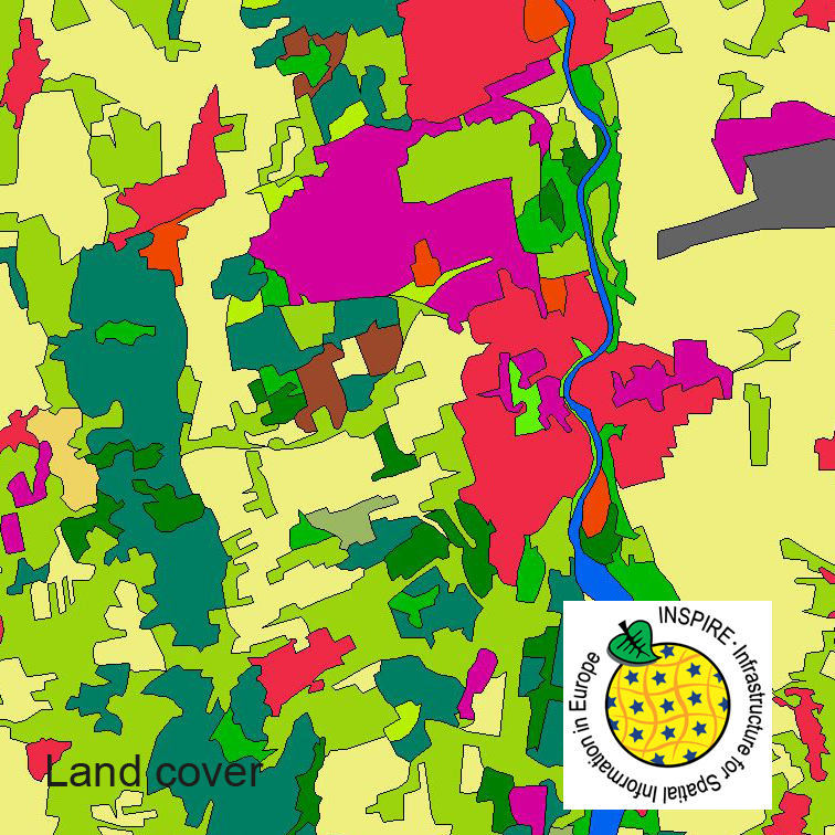
This serie clc5 describes the landscape according to the CORINE Land Cover (CLC) nomenclature. These classes contain mainly information about landcover mixed with some aspects of landuse. CLC5 is based on the more detailed German landcover model (LBM-DE) which uses separate classes for landcover and landuse and attribute-information about percentage of vegetation and sealing. The mimimum unit for an object is 1 ha. For the CLC5 dataset landcover and landuse classes are combined to unique CLC-classes taking into account the percentage of vegetation and sealing, followed by a generalisation process.

Zeitbezug

Creation

24.07.2019

Status

onGoing

Periodizität

continual

Intervall der Erhebung

3 Jahre

Raumbezug

Lage der Geodaten (in WGS84)
SW Länge/Breite NO Länge/Breite
Bundesrepublik Deutschland (000000000000) 6.098°/47.239° 15.579°/55.054°
Koordinaten­system
EPSG 4258: ETRS89 / geographisch
EPSG 31467: DHDN / Gauss-Krüger Zone 3
EPSG 31468: DHDN / Gauss-Krüger Zone 4
EPSG 31469: DHDN / Gauss-Krüger Zone 5
EPSG 25833: ETRS89 / UTM Zone 33N
EPSG 25832: ETRS89 / UTM Zone 32N
EPSG 3044: ETRS89 / UTM Zone 32N (N-E)

Verweise und Downloads

Weitere Verweise (7)

data and services
service "INSPIRE-WFS CORINE Land Cover – 5ha (2012)" (GetCapabilities)
service "INSPIRE-WFS CORINE Land Cover – 5ha (2015)" (GetCapabilities)
service "INSPIRE-WFS CORINE Land Cover – 5ha (2018)" (GetCapabilities)
service "INSPIRE-WMS CORINE Land Cover – 5ha (2012)" (GetCapabilities)
service "INSPIRE-WMS CORINE Land Cover – 5ha (2015)" (GetCapabilities)
service "INSPIRE-WMS CORINE Land Cover – 5ha (2018)" (GetCapabilities)

Nutzung

Nutzungs­bedingun­gen

The data are protected by copyright. In accordance with the "Geodatenzugangsgesetz" (Geodata Access Act), the data are made available free of charge for download and online use, see https://sgx.geodatenzentrum.de/web_public/gdz/lizenz/geozg.pdf. The use of the data is regulat-ed by the "Verordnung zur Festlegung der Nutzungsbestimmungen für die Bereitstellung von Geodaten des Bundes – GeoNutzV" (Regulation on the Determination of the Terms of Use for the Provision of Federal Geodata) of 19 March 2013 (Bundesgesetzblatt Jahrgang 2013 Teil I Nr. 14), see https://sgx.geodatenzentrum.de/web_public/gdz/lizenz/eng/geonutzv.pdf. The source note must be observed.

© GeoBasis-DE / BKG < year of last data download >

Zugriffs­beschränkun­gen

no limitations to public access

Kontakt

Point of Contact

Federal Agency for Cartography and Geodesy service centre

Karl-Rothe-Str. 10-14
04105 Leipzig
Deutschland

dlz@bkg.bund.de
+49 69 6333-2995
+49 69 6333-251
https://www.bkg.bund.de
Distributor

Federal Agency for Cartography and Geodesy service centre

Karl-Rothe-Str. 10-14
04105 Leipzig
Deutschland

dlz@bkg.bund.de
+49 69 6333-2995
+49 69 6333-251
https://www.bkg.bund.de
Publisher

Federal Agency for Cartography and Geodesy

Richard-Strauss-Allee 11
60598 Frankfurt am Main
Deutschland

mailbox@bkg.bund.de
+49 69 6333-1
+49 69 6333-235
https://www.bkg.bund.de

Fach­informationen

Informationen zur Geodatenressource

Identifikator

https://registry.gdi-de.org/id/de.bund.bkg.csw/d923011a-b576-43e1-8cee-666dae93f940

Digitale Repräsentation

Vector

Maßstab 1:x

25000

Fachliche Grundlage

The CLC5 data (minimum mapping unit 5 hectares) are derived from the land cover model for Germany (LBM-DE) by generalization. This dataset, in which the minimum mapping is 1 hectare, contains land cover and land use information for each object. By means of a cross-table the single combinations of land cover and land use attributes are transformed - with regard to the degrees of sealing and vegetation that are stored in LBM-DE as well - into unique CLC codes.

Daten­grundlage

LBM-DE

Herstellung­sprozess

transformation

Zusatzinformationen

Sprache des Daten­satzes

Englisch

Kon­formi­tät
Spezifi­kation der Kon­formi­tät Spezifi­kations­datum Grad der Kon­formi­tät Geprüft mit
COMMISSION REGULATION (EU) No 1089/2010 of 23 November 2010 implementing Directive 2007/2/EC of the European Parliament and of the Council as regards interoperability of spatial data sets and services 08.12.2010
Datenformat
Name Version Kompressionstechnik Spezifi­kation
GML 3.2.1

Schlag­worte

GEMET-Concepts land cover land use
ISO-Themen­kategorien Surface Description
Suchbegriffe Bodenbedeckung CLC Landbedeckung Landnutzung LBM-DE opendata

Informationen zum Metadatensatz

Metadatensatz-ID

D85D3ABC-0612-40AE-8E70-78EDB386DE7F

Datum

10.03.2025

Sprache Metadatensatz

Englisch

Art des Datensatzes

Dataseries

XML Dar­stellung
Metadaten als XML herunter­laden
Point of Contact
dlz@bkg.bund.de

Diese Seite

  • drucken
  • empfehlen

Service

  • Twit­ter
  • Lin­ke­dIn
  • Ins­ta­gram
  • Xing
  • You­tu­be
  • RSS
BKG
  • Kontakt
  • Impressum
  • Datenschutz
  • Erklärung zur Barrierefreiheit

© Bundesamt für Kartographie und Geodäsie - 2024

Nach oben

Hilfe